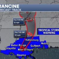
(NEW YORK) — Hurricane Francine made landfall early Wednesday evening in Louisiana, southwest of New Orleans, as a Category 2 storm. Francine has since weakened to a tropical depression as it brings heavy rain to the South.
Here’s how the news is developing:
No fatalities reported in Louisiana
No fatalities have been reported from the storm in Louisiana, Gov. Jeff Landry said Thursday, and he thanked residents for heeding all the warnings.
A Louisiana trooper suffered minor injuries while removing a downed tree from a road Wednesday night, officials said. The trooper was released from the hospital and is recovering at home.
Power outages due to vegetation are the biggest issue in Louisiana, officials said.
Fourteen route-clearance teams are out working to clear debris, officials said.
-ABC News’ Alexandra Faul
Over 340,000 without power in Louisiana
More than 340,000 customers are without power in Louisiana in the wake of Hurricane Francine. About 36,000 customers are without power in Mississippi and 36,000 are in the dark in Alabama.
What to expect next
Francine — which brought a record daily rainfall to New Orleans — is now pushing north, bringing heavy rain, gusty winds and potential tornadoes to the South.
Eight states across the South are under wind and flood alerts, from Louisiana to Missouri.
As Francine moves north, it is expected to slow down and stall. An additional 5 to 10 inches of rain is possible across the South, especially in Alabama, Tennessee, Mississippi and Georgia.
Over 390,000 without power in Louisiana
More than 390,000 customers are without power in Louisiana in the wake of Hurricane Francine. About 66,000 customers are waking up without power in Mississippi and 12,000 are in the dark in Alabama.
Francine weakens to tropical depression
Francine weakened to a tropical depression as it moved over south-central Mississippi Thursday morning.
Francine is now spreading heavy rain across Mississippi, Alabama and the Florida Panhandle.
A tornado watch is in effect for Florida and Alabama.
Heavy rains, ‘severe thunderstorms’ forecast as Francine weakens
The National Weather Service forecast heavy rains and thunderstorms across the southeast through Thursday as Tropical Storm Francine moves north from Louisiana into southern Mississippi.
The National Hurricane Center said Francine was around 20 miles northwest of New Orleans early Thursday, with maximum sustained winds of 50 mph. The tropical storm was moving northeast toward Mississippi at 14 mph.
Francine is expected to bring between 4 and 8 inches of storm rainfall to areas across southeastern Louisiana, Mississippi, far southern Alabama and the Florida Panhandle through Thursday, the NHC said.
“This rainfall could lead to considerable flash, urban and river flooding,” it added.
The NWS warned of “heavy rain and chances for severe thunderstorms” across the affected areas, as well as tornadoes “potentially impacting parts of Alabama and the Florida Panhandle along a slow-moving warm front.”
“The greatest threat for considerable flash flooding exists across parts of northern and central Alabama,” it added, noting the possibility of up to 10 inches of rain.
The NHC also warned of dangerous storm surges. Water could rise by 4 to 6 feet between the mouth of the Pearl River in Louisiana to Ocean Springs in Mississippi, as well as at Lake Pontchartrain.
Three- to 5-foot surges may occur from Ocean Springs, Mississippi to the state border with Alabama, between Morgan City and the mouth of the Mississippi River in Louisiana and at Lake Maurepas, the NHC said.
419,000 without power after Francine landfall
At least 419,942 people were without power early Thursday following the passage of Tropical Storm Francine, which made landfall as a Category 1 hurricane on Wednesday.
PowerOutage.us reported 392,440 people without power in Louisiana and 27,502 in Mississippi as of the early hours of Thursday morning.
Among those affected were 301,000 customers of the Entergy energy company, the firm said on its website. The most pronounced outages were in Louisiana, with the largest impact in coastal areas around New Orleans where Francine made landfall Wednesday.
Jefferson County (68,189), Orleans County (49,975), Lafourche County (36,701), Ascension County (27,038) and Terrebonne County (25,611) were the worst affected in Louisiana, Entergy said.
Francine weakens to tropical storm
After making landfall as a hurricane, Francine weakened to a tropical storm late Wednesday night.
All Hurricane Watches and Warnings have been canceled, but Tropical Storm Warnings continue for parts of Louisiana, Mississippi and Alabama.
The Flash Flood Warning remains in effect in metro New Orleans while heavy rains remain.
By Thursday morning, Francine will be over central Mississippi with heavy rain, gusty winds, and tornado risk extending into Alabama to the Florida panhandle.
The storm is moving northeast at 16 mph while sustaining maximum winds of 65 mph.
Flash Flood Warning issued for New Orleans
Thunderstorms across Louisiana are producing heavy rain across the state, according to the National Weather Service.
Flash Flood Warnings are in effect for “Northwestern Jefferson Parish, Southwestern Orleans, Northern St. Charles Parish and Southwestern St. John The Baptist Parish” until 11:45 PM local time, the NWS said Wednesday evening.
Between 5 to 7 inches of rain has already fallen in the areas, with an additional 2 to 3 inches expected, according to NWS.
Other areas in Louisiana that may experience flash flooding include Hahnville, Metairie, Avondale, Laplace, Marrero, Reserve, Harvey, Timberlane, Jefferson, Gretna, Harahan, Westwego, St. Rose, Destrehan, Ama, New Sarpy, Norco, Luling and Waggaman.
AT&T and T-Mobile report resolution of 911 outage in New Orleans
AT&T and T-Mobile say the issues customers in New Orleans had reported in reaching 911 services in some storm-impacted areas have been resolved.
Those customers who needed emergency services were told to call the 10-digit number instead — 504 671-3600 — according to the NOLA Ready Emergency Alert System.
Francine continues to bring ‘life-threatening’ storm surge
Francine continues to bring life-threatening storm surges and hurricane conditions to southern Louisiana. Heavy rain and gusty winds will stick around while the Category 1 storm is expected to weaken Wednesday evening.
It’s currently moving southeast of Morgan City with maximum sustained winds of 85 mph.
Metro New Orleans is under a Flash Flood Warning and power went out in Slidell, Louisiana.
Causeway Bridge closes to traffic
The famed Causeway Bridge over Lake Pontchartrain in southeastern Louisiana has been closed to traffic due to “thunderstorms, high winds, crosswinds [and] poor visibility,” Causeway Police said.
Francine weakens to Category 1 storm
Francine has weakened to a Category 1 hurricane post-landfall, but continues to bring life-threatening storm surge and hurricane conditions to southern Louisiana.
A peak gust of 97 mph was reported at a weather station in Dulac.
FEMA on storm dangers
As residents in Louisiana hunker down due to Francine, Keith Turi, the associate administrator for the Federal Emergency Management Association, warned of potential hazards in the wake of the storm.
“What many people don’t know is that some of the most dangerous times are those hours right after the storm passes, when you’ve got high floodwaters or power lines down or even operating a generator, making sure you’re doing that safely and keeping it away from your home,” Turi told ABC News Live’s Kyra Phillips.
Turi said the agency has been coordinating with state and local officials for several days as Francine approached and will be prepared to conduct damage assessments on Thursday.
Francine makes landfall as Category 2 storm
Francine has made landfall as a Category 2 hurricane in southern Louisiana with 100 mph winds.
Landfall was about 30 miles south-southwest of Morgan City, in Terrebonne Parish.
Francine strengthens to Category 2
Francine has strengthened to a Category 2 hurricane with 100 mph winds as its eye approaches the Louisiana coast.
Life-threatening storm surge and hurricane conditions are moving onto shore.
Hurricane Francine’s eyewall nears Louisiana coast
Hurricane Francine’s eyewall is nearing the Louisiana coast, bringing hurricane-force winds close to shore.
Francine is now located 115 miles southwest of New Orleans and is moving northeast at 17 mph.
Some voluntary evacuations were issued in Terrebonne Parish, along the Louisiana coastline southwest of New Orleans, Parish President Jason Bergeron told ABC News.
“We’re starting to get some of the first bands coming through. And so we’re just getting everybody hunkered down and getting people to get to safety,” he said. “We opened our shelter last night and then we issued the curfew at 8 a.m. this morning, going to 8 a.m. tomorrow morning.”
Latest forecast
Tropical storm conditions have reached the Louisiana coastline, and life-threatening storm surge and hurricane-force winds are expected to begin in the next few hours leading up to Hurricane Francine’s landfall.
A hurricane watch is in effect in New Orleans, where the worst impacts will be Wednesday afternoon through Wednesday night.
A tornado watch has been issued for parts of Mississippi and Louisiana, including New Orleans.
Storm surge will worsen throughout the day. Up to 10 feet of storm surge is possible in parts of Louisiana; up to 5 feet is possible in the New Orleans area.
Flash flooding is a major threat for Louisiana and Mississippi.
Conditions across Louisiana will start to improve overnight as Francine weakens and moves north into Mississippi.
Francine will rapidly weaken after landfall and become a tropical storm by Thursday, but it’ll still bring heavy rain to the South.
Flash flooding will remain a threat through the end of the week as Francine moves north into Tennessee, Kentucky and Missouri.
The threat for isolated tornadoes will continue through Thursday morning, especially in Alabama and the Florida Panhandle.
-ABC News’ Melissa Griffin
Conditions deteriorating in southern Louisiana
Conditions are deteriorating in southern Louisiana as Hurricane Francine gets closer to landfall.
The storm, located 120 miles southwest of Morgan City, Louisiana, is moving northeast at 13 mph.
Rain bands are moving on shore and the dangerous winds are closing in.
-ABC News’ Melissa Griffin
‘The time to evacuate has now passed’
With hours to go until Hurricane Francine makes landfall in Louisiana, “the time to evacuate has now passed,” Jacques Thibodeau, the director of the Governor’s Office of Homeland Security and Emergency Preparedness, said at a news conference.
“It is now time to go down and hunker down,” he said. “We are no longer in the, ‘Prepare for a hurricane’ — we are now in the, ‘Respond to a hurricane.'”
The White House has approved an emergency declaration for the state. The Louisiana National Guard expects to have 2,400 guardsmen ready for the storm, along with 58 boats, 101 high water vehicles and 61 aircrafts, officials said.
Louisiana Gov. Jeff Landry said he’s been in contact with the Federal Emergency Management Agency and the Army Corps of Engineers, and said he’s fully confident in all state and federal agencies working together before, during and after the hurricane.
Landry also encouraged residents to “take advantage of the power that you have currently and make sure that you charge all of your devices.”
-ABC News’ Alexandra Faul
New Orleans residents should start sheltering in place
Residents in New Orleans should stay off the roads beginning at noon ET and remain sheltered in place until Thursday morning, Mayor LaToya Cantrell said.
“Conditions will worsen throughout the day—stay safe!” she tweeted.
Latest forecast
Francine is churning north as a Category 1 hurricane with 90 mph winds.
Landfall is forecast Wednesday afternoon or early evening as a Category 1 hurricane near Houma, Louisiana.
Life-threatening storm surge, flash flooding and hurricane-force winds are bearing down on Louisiana.
The storm surge could reach 10 feet along the Louisiana coast and wind gusts could hit 70 mph in New Orleans.
“Ensure you are in a safe location before the onset of strong winds or possible flooding,” the National Hurricane Center warned.
By Thursday morning, Francine will be bringing rain and gusty winds to Mississippi, and potential tornadoes to Alabama and the Florida Panhandle.
Throughout the day Thursday, the heavy rain and tornado threat will move into northern Alabama, Mississippi and Tennessee. Flash flooding is possible near Memphis and Nashville.
-ABC News’ Max Golembo
Weather warnings for Gulf Coast states
A raft of warnings was issued for cities in Louisiana, Mississippi and Alabama ahead of Hurricane Francine’s expected landfall on Wednesday afternoon.
A hurricane watch was issued for New Orleans, with hurricane warnings for Morgan City and Houma on Louisiana’s Gulf Coast.
Tropical storm warnings are in place further east, covering cities including Biloxi, Mississippi, and Mobile, Alabama.
Storm surge warnings were announced for both Biloxi — where water may rise up to 5 feet — and Mobile, where water levels may rise by up to 4 feet.
Francine is expected to make landfall as either a high-end Category 1 or low-end Category 2 hurricane, with winds between 90 and 100 mph, the National Hurricane Center said. The Category 2 classification begins with winds of 96 mph.
Landfall may bring tornadoes in areas around New Orleans, Biloxi, Mobile and Pensacola, Florida.
Heavy rain may cause flash flooding from New Orleans all the way up to Jackson, Mississippi through to Wednesday night. As the storm moves into Mississippi on Thursday, it is forecast to produce flash flooding and gusty winds.
Francine is expected to stall through Thursday night into Friday morning, bringing heavy rain to Memphis, Nashville and Paducah, Kentucky.
Francine 295 miles from Louisiana coast
Hurricane Francine is expected to make landfall southwest of New Orleans as a Category 1 hurricane on Wednesday afternoon.
As of early Wednesday, Francine was 295 miles southwest of Morgan City, Louisiana, heading northeast at 10 mph.
Data collected by Air Force Reserve Hurricane Hunter aircraft indicated that the storm strengthened in the early hours of Wednesday, with maximum sustained winds close to 85 mph — up from 75 mph on Tuesday night.
New Orleans under Hurricane Watch
Emergency officials in New Orleans, Louisiana, warned residents on Tuesday that they should be prepared to shelter in place as Hurricane Francine approached landfall.
A Tropical Storm Warning and Hurricane Watch were issued for areas along the southern Louisiana coast, including New Orleans. A Flood Watch was also issued in Orleans Parish through Thursday morning, the city said.
Mayor LaToya Cantrell signed an emergency proclamation.
“The storm track has shifted more towards the east, which has the potential to worsen impacts for the city, but the storm remains disorganized,” the city said in a statement.
Copyright © 2024, ABC Audio. All rights reserved.


