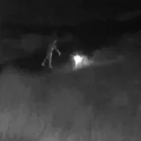
Deschutes County Sheriff’s Office reports numerous Law Enforcement and Fire agencies are actively working a 20-acre wildfire east of Highway 97, north of Cooley Road, in the Juniper Ridge area.
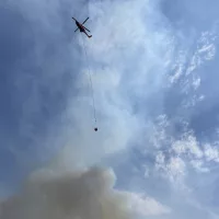
There is currently heavy use of aircraft and other fire apparatus actively attempting to extinguish the fire.
Level 3 evacuations for the area have been completed. Temporary evacuation point has been designated as Mountain View High School. 2755 N.E. 27th Street. Red Cross has established an evacuation shelter.
August 2, 2024 at 08:15pm Updated: Mile Marker 132 fire
Current evacuation levels are as follows:
Level 3 Go Now: Juniper Ridge area and all residences on the east side of Hwy 97 north of Hilltop trailer park to the COID power generation facility.
Level 2 Be Set: Residential north of Cooley Rd. between NE 18th St and Hwy 97
Level 1 Be Ready: NE 18th, Talus Place, and residents along the west side of Deschutes Market Rd.
***Actualización 2 agosto, 2024***
Los niveles de evacuación actuales son los siguientes:
Nivel 3 Ir ahora: La zona Juniper Ridge y todas las residencias en el lado este de la autopista 97 al norte del parque de hogares móviles hasta la instalación de generación de energía COID.
Nivel 2 Estar listo: Áreas residenciales al norte de Cooley Road entre NE 18th Street y la autopista 97
Nivel 1 Prepárate: NE 18th, Talus Place, y residentes a lo largo del lado oeste de Deschutes Market Road.
Encuentre las zonas de evacuación actuales en: Deschutes.org/emergency
Ensure you and your family are registered for emergency alerts. Sign up or update your information at: deschutesalerts.org
Find current evacuation areas at: deschutes.org/emergency
Find information regarding fires at: CentralOregonFire.org
Prineville District BLM is now in unified command of the Milemarker 132 fire which started this afternoon & is burning between Bend & Redmond. The fire is showing a rapid rate of spread with spotting ahead. Multiple aircraft have been ordered and air attack is currently on scene.