(NEW YORK) — A new storm — which will strengthen into Hurricane Helene — is taking aim at Florida, where it’s forecast to make landfall along the Big Bend area as a hurricane on Thursday.
Here’s how the news is developing:
State of emergency declared in 61 Florida counties
Helene is forecast to be a major hurricane by the time it makes landfall Thursday night, Florida Gov. Ron DeSantis warned Monday.
A state of emergency has been declared in 61 of Florida’s 67 counties, DeSantis said.
“The Big Bend and Panhandle should be especially prepared for a direct impact,” the governor said, and he urged residents to know their evacuation zone.
“You have time to be able to put this place into place,” DeSantis said, noting Helene’s impacts could begin Wednesday.
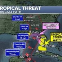
Latest forecast
Helene will strengthen to a hurricane Tuesday night, and rain is expected to begin in Florida Wednesday afternoon into Thursday morning.
On Thursday evening, Helene will make landfall along Florida’s Big Bend area, located between Tallahassee and Gainesville.
Storm surge could reach up to 15 feet in the Big Bend area.
Heavy rain and strong winds are also major threats.
A hurricane watch is in effect for Florida’s Gulf Coast and a tropical storm watch was issued from Orlando to the Florida Keys.
By Thursday night into Friday, the storm will quickly push into Georgia with very heavy rain, gusty winds and possible flash flooding.
This weekend, the storm will stall over the Mid-South, bringing heavy rain and possible flooding to the Tennessee, Ohio and Mississippi River Valleys.
A flood watch has been issued in Florida from Fort Myers to Tampa to Tallahassee, as well as in southern Georgia and Alabama.
Copyright © 2024, ABC Audio. All rights reserved.