(NEW YORK) — Hurricane Debby is roaring across Florida as a Category 1 hurricane after making landfall Monday morning.
Here’s what to expect:
Flash flood warnings have been issued from Cedar Key, Florida, to Venice, Florida.
More than 10 inches of rain already fell in the Tampa area and more than 1 foot of rain was recorded just south of Sarasota.
On Monday, Debby will bring very heavy rain from Gainesville and Jacksonville, Florida, up to Savannah, Georgia, where more than 20 inches of rain is possible.
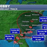
The storm surge will be the highest — up to 10 feet — in Florida’s Big Bend area, from Keaton Beach to Cedar Key.
By Tuesday, Debby is expected to stall over the Southeast, bringing potentially historic rainfall to Georgia and South Carolina. Up to 30 inches of rain is possible through Thursday.
The National Oceanic and Atmospheric Administration has issued a rare “high risk” warning for extreme flooding in Florida, Georgia and South Carolina over the next two days.
The rainfall from Debby may approach Georgia’s record of 27.85 inches from Tropical Storm Alberto in 1994.
Debby’s remnants could then move up to North Carolina and Virginia by Friday and this weekend.
Copyright © 2024, ABC Audio. All rights reserved.