(NEW YORK) — Beryl remains a tropical storm with winds of 60 mph as it churns in the Gulf of Mexico as of Saturday morning, but it is expected to strengthen before hitting Texas on Sunday with potential Category 1 strength.
The land interaction from Beryl’s time over the Yucatan Peninsula did a number on the storm, weakening it from a hurricane to a disorganized tropical storm during the day Friday.
On Saturday, Beryl may take some time to recover, but is forecast to begin strengthening by the end of the day. The storm is moving into favorable conditions for hurricanes, with warm water and limited wind shear.
The track from the National Hurricane Center takes Beryl towards the Texas coast by late Sunday night into early Monday, likely as a strong Category 1 Hurricane. Currently, the most likely landfall location is around Matagorda Island, just east of Corpus Christi, but that will likely need to be adjusted as the storm’s track becomes more “fine-tuned” in the next day or so.
A Hurricane Watch is in effect in Texas from the Rio Grande Valley to San Luis Pass, just west of Galveston Island, with a Storm Surge Watch from the mouth of the Rio Grande northward to High Island, Texas.
Storm surge is forecast to be 3 to 5 feet in Corpus Christi and Matagorda Bay, and 2 to 4 feet in Galveston Bay. These numbers are subject to change depending on the exact track and intensity of the storm as it approaches landfall.
Residents along the Texas coast need to be prepared for a powerful hurricane with life-threatening storm surge, damaging winds, and significant flooding.
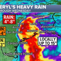
Flooding rain is often the most impactful aspect of tropical systems. In terms of rainfall amounts, much of southeastern Texas is looking at 5 to 10 inches, with locally higher amounts up to 15 inches. Most of this rain will fall on Monday and Tuesday.
Copyright © 2024, ABC Audio. All rights reserved.


