Back in the year 1700, a powerful magnitude 9.0 earthquake struck along the Cascadia Subduction Zone (CSZ), which extends from Vancouver Island in British Columbia to Cape Mendocino in California. This earthquake released energy equivalent to about two billion tons of TNT, leading to significant impacts along the Oregon coast, the effects of which are preserved in the oral traditions of native communities and evident in the landscape. Damage from a CSZ earthquake would affect the entire region, causing several minutes of intense shaking along the Oregon coast, tsunamis tens of feet high, and shaking extending through the Cascade Range, with lesser impacts in eastern Oregon.
The global study of earthquakes has revealed that they are cyclical in nature, driven by the movement and interactions of tectonic plates. As such, the CSZ, where the 1700 earthquake occurred, has been accumulating energy since the last event that will be released in future earthquakes. To understand and reduce the risks associated with CSZ events, DOGAMI scientists study past earthquakes and faults, map tsunami evacuation zones, identify landslide-prone areas, and conduct risk assessments.
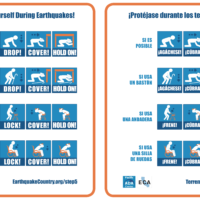
It is not possible to predict when the next Cascadia earthquake will happen. However, in the event of an earthquake, emergency managers advise immediate safety measures like dropping, covering, and holding on followed by evacuation for individuals in tsunami zones. Considering the expected impact, Oregonians should be aware of this hazard and prepare by having enough food, water, and supplies for at least two weeks, following guidance from the Oregon Department of Emergency Management.
Resources to help Oregonians learn about earthquakes and associated hazards:
ShakeAlert: An early-alert system that will send notifications to mobile devices and emergency alert systems in the event of a potentially damaging earthquake. https://www.shakealert.org/
Oregon Tsunami Clearinghouse: Access to a wide variety of tsunami information, including evacuation maps, maritime brochures, educational materials, and planning guidance. https://www.oregon.gov/dogami/tsuclearinghouse/Pages/default.aspx
NANOOS Tsunami Evacuation Zones: Tsunami evacuation zone maps along the Oregon and Washington coasts. https://nvs.nanoos.org/TsunamiEvac
DOGAMI Publications: Freely available publications on geologic hazards and earth science information from the Oregon Department of Geology and Mineral Industries. https://www.oregon.gov/dogami/pubs/Pages/pubsearch.aspx
HazVu: Oregon’s Geologic Hazards Map Viewer provides geologic hazard data in an online map view. https://gis.dogami.oregon.gov/maps/hazvu/
Oregon Department of Emergency Management: Learn more about what to do in event of an earthquake, and find advice and guides on how individuals, communities, and businesses can prepare.
https://www.oregon.gov/oem/hazardsprep/pages/earthquakes.aspx
###