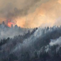
Firefighters continued to be challenged by limited access and smoky conditions on the Pete’s Lake Fire that broke out Sunday. In spite of intermittent help from air tankers and helicopters when the smoke lifted, the fire grew to approximately 300 acres. Yesterday’s conditions indicated the fire has potential to spread east toward the Cascade Lakes Hwy over the next week with periods of increasing winds. A Type 2 Incident Management Team is on order to relieve local and national initial attack resources, and is expected to take control of the fire on Tuesday.
In the event that the fire made a significant run, the Deschutes County Sheriff’s Office issued a level 3 evacuation notice (go now) for areas west of the Cascade Lakes Highway, between the Lucky Lake Trailhead and Mirror Lakes Trail. As a precaution, a level 1 (get ready) notice was issued for areas around Elk, Hosmer, Lava and Little Lave Lakes. This includes areas east of the Cascade Lakes Hwy from Blue Lagoon north to Quinn Meadows. In conjunction with these notices, a joint Willamette/Deschutes Forest Closure covering the affected Wilderness surrounding the fire is in place. Deschutes National Forest Recreation and Wilderness Staff have been sweeping trails in the evacuation area for hikers.
Smoke from this fire and others burning in the Cascades is decreasing the air quality in Central Oregon . In some areas the smoke seems strong enough to make it appear that a wildfire is close and not on the other side of the mountains. There are no evacuation orders besides the ones in place for the Pete’s Fire. The air quality in the Bend area Monday morning is hazardous to very unhealthy: https://aqi.oregon.gov/
To receive notifications about emergencies in Deschutes County, please register for Deschutes Alerts at https://member.everbridge.net/892807736723736/login


