(LOS ANGELES) — Several dangerous and potentially catastrophic weather events will be happening simultaneously over the country on Sunday, forecasts show.
The events include flash flooding, extreme heat and poor air quality from wildfires, prompting the National Weather Service to issue alerts for more than 100 million people.
Tropical Storm Hilary could wreak havoc in the West
The threats from Tropical Storm Hilary as it approaches the West Coast could prove to be historic.
The system is the first tropical storm to reach California since 1997.
Once a Category 4 hurricane, Hilary weakened to a tropical storm on Sunday morning, when it was about 220 miles south-southeast of San Diego and moving 25 mph to the north-northwest.
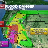
Hilary is expected to move through Southern California on Sunday afternoon, bringing catastrophic and life-threatening flooding over portions of the Southwest through Monday, forecasts show. The peak of the rainfall will occur Sunday afternoon and evening.
The outer reaches of the storm have already begun to soak parts of the Southwest. About a quarter of an inch of rain has already fallen in Palm Springs on Sunday morning, while San Bernardino has seen about .8 of an inch, according to the 8 a.m. PT advisory from the National Hurricane Center.
The storm system could weaken again to a tropical depression as it passes through Death Valley on Sunday evening and then downgrade to a post-tropical cyclone as it reaches Oregon on Monday morning.
Rainfall amounts of 3 to 6 inches, with isolated amounts of 10 inches, are expected across portions of southern California and southern Nevada. Some regions will get one or two years’ worth of rain in a matter of days, with the potential for 3 inches to fall in just an hour in some places, forecasts show.
Hilary will likely become the wettest known tropical cyclone, post-tropical cyclone, or tropical cyclone remnant to impact Nevada, Idaho and Oregon.
Across portions of Oregon and Idaho, rainfall totals of 1 to 3 inches, with 5 inches forecast in some areas, are expected through Tuesday morning, which will likely cause significant flash flooding.
The heavy rainfall combined with high winds expected at higher elevations could lead to mudslides and landslides across portions of the West, which would be exacerbated where trees uproot due to oversaturated soil, the weather service said.
A tornado or two is possible through Sunday evening over parts of the lower Colorado River Valley, Mojave Desert and Imperial Valley regions.
Wildfires causing poor air quality in Pacific Northwest
Hazardous air quality is currently blanketing the majority of the Pacific Northwest as wildfires force people to evacuate their homes.
The Gray Fire has scorched nearly 11,000 acres in Spokane County, Washington, and was 0% contained on Sunday morning. Nearly 200 structures have been lost to the flames, and parts of Interstate 90 are closed due to low visibility from the thick smoke, officials said.
The Oregon Road Fire, also in Spokane County, has burned more than 8,000 acres and was 0% contained on Sunday morning.
The Winona Fire in Whitman County, Washington, is 40% contained so far and has burned through more than 2,500 acres.
The fires are causing poor air quality through much of the region, especially in Washington state and northern Idaho, which are covered in hazy, orange skies. Parts of Northern California are also experiencing poor air quality.
Washington Gov. Jay Inslee has issued a state of emergency proclamation due to the wildfires and smoke.
Extreme heat continues to affect large swath of US
Some regions in the U.S. cannot get a break from the sweltering heat.
Heat alerts are currently in effect for more than 102 million Americans across 18 states from Texas to Wisconsin, including nearly all of Louisiana, Arkansas, Missouri, Iowa and Illinois.
Thirty-six locations across the middle of the U.S. could tie or break daily high temperature records on Sunday, including Houston; Austin, Texas; Tulsa, Oklahoma; and Mobile, Alabama.
Dallas could reach its hottest temperature since 2011 on Sunday if it reaches 110 degrees, forecasts show. The city has only hit 110 a dozen times since records began in 1898.
The scorching temperatures are continuing from Saturday, when daily records were broken in Wichita, Kansas, at 111 degrees; Shreveport, Louisiana at 109 degrees; Dallas at 108 degrees; Oklahoma City at 107 degrees; and Houston at 103 degrees.
Seventeen people were hospitalized Saturday after overheating at a Snoop Dogg concert at Cynthia Woods Mitchell Pavilion in The Woodlands, Texas, located about 30 miles north of Houston, ABC Houston station KTRK reported.
Triple-digit temperatures will continue at many of these high-century marks for much of the week ahead, as the heat dome continues from the Gulf to the Midwest.
ABC News’ Asia James and Vanessa Navarrete contributed to this report.
Copyright © 2023, ABC Audio. All rights reserved.


