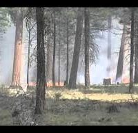
If conditions remain favorable, fuels specialists on the Bend-Fort Rock Ranger District plan to conduct an 875-acre prescribed burn approximately 7 miles northwest of the Fort Rock community on National Forest lands on Thursday. Ignitions may last up to two days.
Fuels specialists are implementing the understory burn to reduce hazardous fuels accumulation decreasing the risk of high-intensity wildfire in the area. The unit previously underwent prescribed fire treatments in 1999. The prescribed burn reintroduces and maintains fire within the Ponderosa pine fire-adapted ecosystem.
Smoke will be visible from the Fort Rock area and along Highway 31 potentially degrading visibility along the highway. Impacted forest roads will be signed as appropriate. Hunters in the area may experience periods of smoke as well.
Fire management officials work with Oregon Department of Forestry smoke specialists to analyze weather conditions and anticipated smoke dispersion to determine burn dates. When smoke is present, motorists should reduce speed and turn on headlights. All efforts will be made to limit smoke impacts to area neighborhoods and communities. The possibility exists for smoke to settle in low-lying areas due to cool night-time temperatures. Residents in areas near burn operations are encouraged to close windows at night to avoid possible smoke impacts.