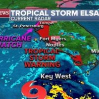
(NEW YORK) — The latest radar shows Tropical Storm Elsa is pounding Key West with heavy rain and gusty winds from 50 to 60 mph as it moves through the region.
A hurricane watch has been issued for St. Petersburg, Florida, and north through the Big Bend area of the Sunshine State.
A tropical storm warning has also been issued from the Keys to Fort Myers to Tampa on Tuesday as a tropical storm watch has been extended now into South Carolina and coastal Georgia.
The most recent satellite of the storm indicates several unfavorable factors about the upcoming storm.
Elsa is due to pass the Tampa Bay area late Tuesday and into the early morning hours of Wednesday when it is forecast to make landfall just north of Tampa Bay with winds of 70 mph.
In order for the storm to be considered a hurricane, winds need to be at 74 mph or higher, which is why the National Hurricane Center has issued a hurricane watch for St. Petersburg.
The storm’s landfall is forecast to be around 3 to 5 a.m. Wednesday, and storm surge could reach up to 5 feet in the Tampa Bay area, which is very susceptible to flooding due to the coastal low-lying area.
A flood watch has been issued for a large swath of Florida — from Naples to Jacksonville — and reaching into southern Georgia.
The heaviest rainfall is expected when the storm makes landfall north of Tampa, with 6 to 10 inches of rain possible and possible flash flooding.
After Florida, Elsa is expected to join a cold front and will become a hybrid storm system that will bring heavy rain and gusty winds to the Carolinas, Georgia and into the Mid-Atlantic states by the middle and end of this week.
Elsa is expected to reemerge off the New Jersey coast and bring heavy rain and gusty winds to Atlantic City, New York City, Long Island and southeastern New England, including Boston and Cape Cod, in a few days.
Copyright © 2021, ABC Audio. All rights reserved.


