Slater and Devil Fire Morning Update
September 15, 2020
HAPPY CAMP, CALIFORNIA— 10 a.m.
East and northeast winds are predicted to clear smoke out of much of the fire area later today. Vegetation remains exceptionally dry and receptive to fire, and fire activity is expected to pick up with these winds.
On the southern end of the fire, the town of Happy Camp is beginning to repopulate as it has deemed safe for return. Residents can expect to see UAS (Unmanned Aircraft Systems) flying in the Indian Creek area today, working on assessments of damaged or destroyed structures.
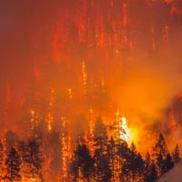
The Slater Fire remained on the north side of control lines along Highway 96 between Happy Camp and Seiad overnight. Night shift firefighters watched carefully overnight for rolling material that could cause fire spread across the road. The fire is burning into patchy fuels in the 2012 Goff Fire footprint, with some heavier fuels and more intense burning along the northeast edge of this footprint. The fire is still two to three miles from Fort Goff and Thompson Creek areas along the Highway 96 Corridor.
Increased fire activity is anticipated around Seiad today. Firefighters in that area will focus on building indirect line along the north side of Seiad as the Devil Fire continues to slowly spread and the Slater Fire moves east. Incident Management Team 10 was able to dedicate some additional resources to help pick up the pace of this task. Meanwhile, direct line construction along the eastern flank of the Devil Fire will also begin today, tying into the Pacific Crest Trail.
On the Oregon side of the Slater Fire, a precipitous temperature rise and humidity drop occurred late in the day yesterday– bumping fire northward in the Illinois Valley, east of Highway 199. Firefighting resources are beefing up primary, secondary, and contingency firelines today. Firefighting resources remained in Dwight Creek area last night to monitor fire activity and do some defensive firing as needed. Engines patrolled south of Takilma, where communities saw some increased fire activity yesterday, but fire behavior decreased there overnight. No structures were lost during the flareup yesterday. Similar weather patterns and fire activity are predicted there today.
Near Gasquet, firelines are holding along Knopki Road, despite limited available resources there. Firefighters worked to strengthen control lines along Monkey Ridge and Oregon Mountain Road to prevent the fire’s spread into communities southwest of the fire. Repeaters on Monkey Ridge are threatened by the fire, according to operational reports.
Incident Management Team 10 is readying to transfer command of the northern and western sides of the Slater Fire to an incoming Type 1 Team from the Northern Rocky Mountains, while retaining command of the south and east sides of the Slater Fire. The transfer of command for the north zone of the Slater Fire to the Northern Rockies Team occurs tomorrow at 6 a.m. Team 10 ordered additional radio communication repeater kits to ensure that the various sides of the fire can stay in good contact and coordination.
Due to extreme fire danger, all National Forests in California closed September 9, and remain closed. More details on these closure orders, along with fire restrictions orders, can be found on National Forest websites and on
InciWeb.
Highway 199 remains closed from O’Brien south almost to Gasquet. Highway 96 is now open to one-way controlled traffic. Drivers traveling this section of highway should expect delays and use caution due to poor visibility. Other highways in Oregon are also being impacted by the smoke.
EVACUATION INFORMATION:
· Evacuation order/warning info and other resources for Josephine County can be found by calling Josephine County Fire Information Center 541-474-5305 (7am-10pm) or online at:
| Lionshead Fire Update – Tuesday, September 15, 2020 – 9:00 a.m. |
Weather and Fire Behavior: Today winds will be light and dense smoke will not dissipate to the degree expected. Temperatures will be in the 70s with slightly higher humidity than yesterday. Firefighting efforts have been challenged both by lack of air support and unusually active fire behavior overnight. Active fire behavior is anticipated today, especially at higher elevations. There will also be a change in wind direction, from southwest winds yesterday to light east winds early today and north and northwest winds later in the afternoon. Some precipitation is possible Thursday.
Current Situation: Aviation assets were still unable to fly yesterday and flights will likely not be possible today because of poor visibility. The northeast portion of the fire on the Warm Springs Reservation continues to experience the most active fire growth. Crews worked there yesterday and through the night to build containment line and conduct strategic firing operations. Lionshead Fire Managers met yesterday with personnel from the Riverside Fire to coordinate their containment strategies and evaluate options for connecting road systems on the Mt. Hood National Forest to those on the Reservation. On the western edge of the fire, crews continued structure protection and damage assessments in Detroit Lake, Marion Forks and along the Highway 22 Corridor. Elsewhere, active fire behavior was seen just north of the Mt. Jefferson Wilderness boundary to the south and near Sisi Butte and Hawk Mountain, to the north and northwest. Crews constructed contingency fire line along the southern boundary yesterday.
Today’s Activities: Fire managers continue to coordinate closely with the Confederated Tribes of the Warm Springs on firefighting efforts. On the Warm Springs Reservation, crews plan to conduct strategic firing operations working from roads and dozer lines for containment. Crews will also continue yesterday’s work on structure protection and mop-up in the Olallie Lakes area. Structural crews will keep working in and around Stahlman and continue mop-up and structure protection around the impacted communities to the west. To the south of the fire, crews will scout for containment options west of the lava beds in the Mt. Jefferson Wilderness, taking advantage of features such as trails and old fire scars. Most of the eastern perimeter of the fire will be in patrol status today, meaning that mop-up there has been successful but crews will maintain watch to detect and suppress any spot fires.
Evacuations: The most current information on statewide evacuation information can be found at the Oregon Office of Emergency Management’s interactive database: https://www.oregon.gov/oem/emops/Pages/RAPTOR.aspx. Updates on evacuations on the Warm Springs Reservation can be found on the Warm Springs Police Facebook page.
Closures: For public and firefighter safety, roads and trails on the southwest portion of the Warm Springs Reservation near the fires remain closed to the public. Forest closures are in place for Deschutes, Mt. Hood and Willamette National Forests. Deschutes NF Alerts Willamette NF Alerts Mt. Hood NF Alerts
FOR ADDITIONAL FIRE INFORMATION: Fire Information: 971-277-5075
TripCheck: https://www.tripcheck.com/
Inciweb: https://inciweb.nwcg.gov/incident/7049/
Facebook: www.facebook.com/LionsheadFire
Email: 2020.lionshead@firenet.gov
|
| Start Date: 8/16/2020 |
Approx. Size: est. 168,097 ac. |
Resources on the Fire: |
Cooperating Agencies: |
| Cause: Lightning |
Containment: 5% |
47 Crews |
Marion Co. Sheriff |
| Incident Commander: |
Total Personnel: 1182 |
49 Engines |
Linn Co. Sheriff |
| Noel Livingston
Pacific Northwest Team 3
|
Approx. Distance:
14 miles west of Warm Springs
|
9 Dozers
29 Water Tenders
11 Helicopters |
Jefferson Co. Sheriff
Deschutes Co. Sheriff |
New Wildfire on Klamath National Forest
YREKA, CALIFORNIA—A new wildfire was detected September 14, 2020 in the Trinity Alps Wilderness about 6 miles southwest of Callahan, California. The Fox Fire was estimated at 10 acres in size when identified by aircraft yesterday–and is currently estimated to be 100 acres in size—due in large part to strong southwest winds. Both ground and air resources are currently working to contain the fire. Part of the ground and aircraft resources are from the Slater and Devil Fire.
The start of this wildfire is a prime example of the need to be extra careful about anything that can start a wildfire. Valuable resources are being diverted from the Slater Fire to help fight this new fire. Please remember the Klamath National Forest is closed temporarily due to extreme fire conditions. You can still drive through the Forest but you cannot get off the road.
Please be sure that safety chains between your tow vehicle and trailer are not dragging on the pavement and creating a shower of sparks. Check tire pressure, tire condition and wheel bearings to minimize the risk metal rims creating sparks. If you need to make an emergency stop and must pull off the road–be aware that hot catalytic converters can quickly ignite tall vegetation beneath your vehicle.