NEW FIRES
The Eagle Complex was reported Tuesday afternoon burning approximately 16 miles northeast of Baker City and 10 miles east of Medical Springs, Oregon.
Three fires comprise the complex, approximately 120 acres, 40 and 10 acres in size and burning on the Wallowa-Whitman National Forest as well as private lands protected by Oregon Department of Forestry.
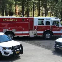
Resources: 4 engines and two 10-person hand crews as well as several aviation resources, with additional resources on order.
An Interagency Type 3 Management team is assuming command of the fire today.
Fire officials want to remind everyone that the current fire danger rating remains at EXTREME and Public Use Restrictions involving campfires and chainsaw use are in effect. Regulated closures are in effect on State and private lands protected by Oregon Department of Forestry (ODF) in northeast and central Oregon.
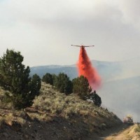
Photo – Courtesy of Tanner O’Grady
On the Wallowa-Whitman National Forest lands Public Use Restrictions are in effect, including campfire restrictions and use of chainsaws.
The Vale BLM Unit is also managing several large fires in the Burnt River area; additional information can be found at: http://www.blm.gov/or/districts/vale/fire/report-fire.php.
FIRES CURRENTLY BURNING ON ODF-PROTECTED LANDS
The lightning-caused Cornet Fire (EOA) near Hereford, Oregon is currently burning approximately 7 miles east of Hereford, Oregon on the Wallowa-Whitman National Forest and Vale BLM District as well as on private lands protected by Oregon Department of Forestry.
The fire has grown to approximately 5,000 acres and with just over 100 personnel on scene. Additional resources are on order.
If you see local news happen, call the Horizon Broadcasting Group News Tip Hotline at 541-323-NEWS, or email us.