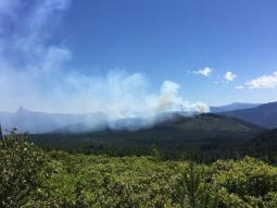
Diamond Lake, Ore. – The Bunker Hill Complex is located 15 miles north of Diamond Lake, in Southern Oregon. The fire complex resulted from lightning activity on June 26th and consists of one larger fire called the Bunker Hill Fire and six small fires ranging from 1/10 to 9 acres, all within the Umpqua National Forest.
Operations –All burnout operations have been completed on the Bunker Hill Fire. Mop-up (extinguishing all burning material) up to 200 feet from the fire perimeter is occurring. Hand crews are using water from fire hoses along containment lines to accomplish this important task.. The four smaller fires are fully lined, mopped up, and in a monitoring status. The remaining two small fires will be staffed today. Release of excess fire fighting equipment and personnel is ongoing.
Weather and Fire Behavior – Temperatures are expected to be slightly cooler today and reach a high in the mid 90’s. The relative humidity is predicted to increase to around 28%. Thunderstorms may happen late in the afternoon far to the south of this fire in northern CA and southern OR. Tomorrow they are expected to move north and possibly over the fire area. Active smoldering is expected to continue within containment lines and flare ups of isolated pockets of vegetation may occur in the afternoon. Smoke will be visible and intermittent north of FS Road 2612.
Campground Closures: he Forest Service Campgrounds Inlet, and Crystal Springs will be reopened at noon today. The Lemolo Lake Resort and Forest Service Campgrounds Poole Creek, and East Lemolo, continue to be open. The Forest Service Campground at Bunker Hill remains closed to protect public health and safety. See below for trail, road and area closures.
Trail Closure: NU Trail #1414 is closed from the junction of FS Road 2610 and Lemolo Lake Dam, continuing southeasterly to the Junction of FS Road 700.
Road Closure: FS Road 2612 is closed from the Junction of FS Road 2610, southeast to the junction of FS Road 2614.
Area Closure: The area closure has been reduced to an area described as: Beginning where White Mule Creek crosses FS Road 2610, continuing northeast along White Mule Creek to the junction of FS Road 700, then southeast along the 700 road to the junction of FS Road 2612, continuing west along FS Road 2612 to the junction of FS Road 2614 westerly along the north shoreline of Lemolo Lake, to the beginning point of FS Road 2610 and White Mule Creek crossing.
Detailed closure information is located at: http://www.fs.usda.gov/main/Umpqua.
If you see local news happen, call the Horizon Broadcasting Group News Tip Hotline at 541-323-NEWS, or email us.


